Intuitive GIS Mapping Solutions

SymGEO_white_vertical_transparent

TELL A STORY TO REMEMBER WITH YOUR DATA.

SymGEO provides Geographic Information System (GIS) mapping solutions and digital community engagement platforms using Esri technology. Located near Washington, DC, we specialize in ArcGIS solutions benefiting state and local government and Nonprofit organizations. This includes data setup, application configuration, design, deployment, and platform maintenance. As a small, minority, woman-owned business, we help our clients communicate informed decisions and engage with their audience. As a GSA IT Schedule 70 holder, we offer competitive rates and welcome teaming opportunities.

EVERY MAPPING CHALLENGE HAS A UNIQUE SOLUTION.

Schedule your free consultation today.

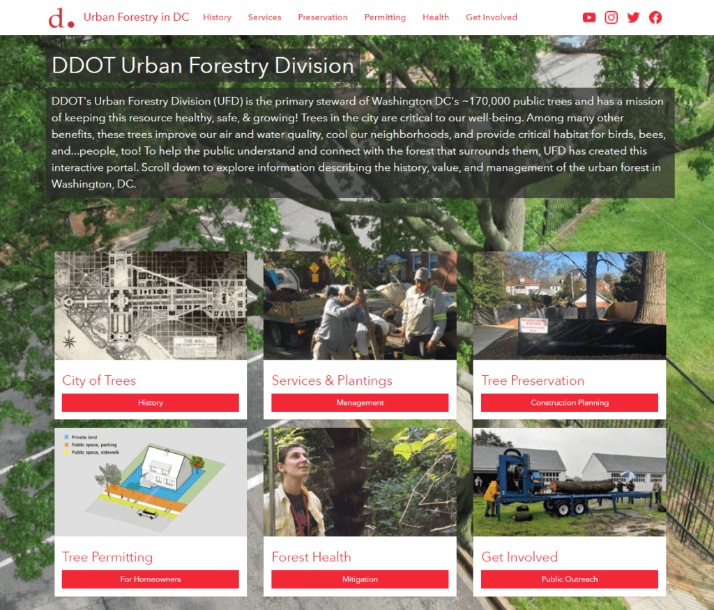
"SymGEO is a remarkably flexible and responsive company. They listen carefully to requirements and deftly blend customer vision with technological capabilities."
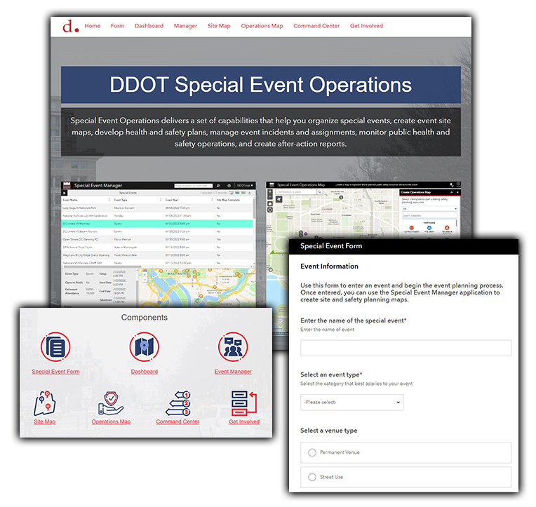
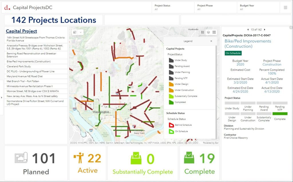
- District Department of Transportation, Urban Forestry Hub

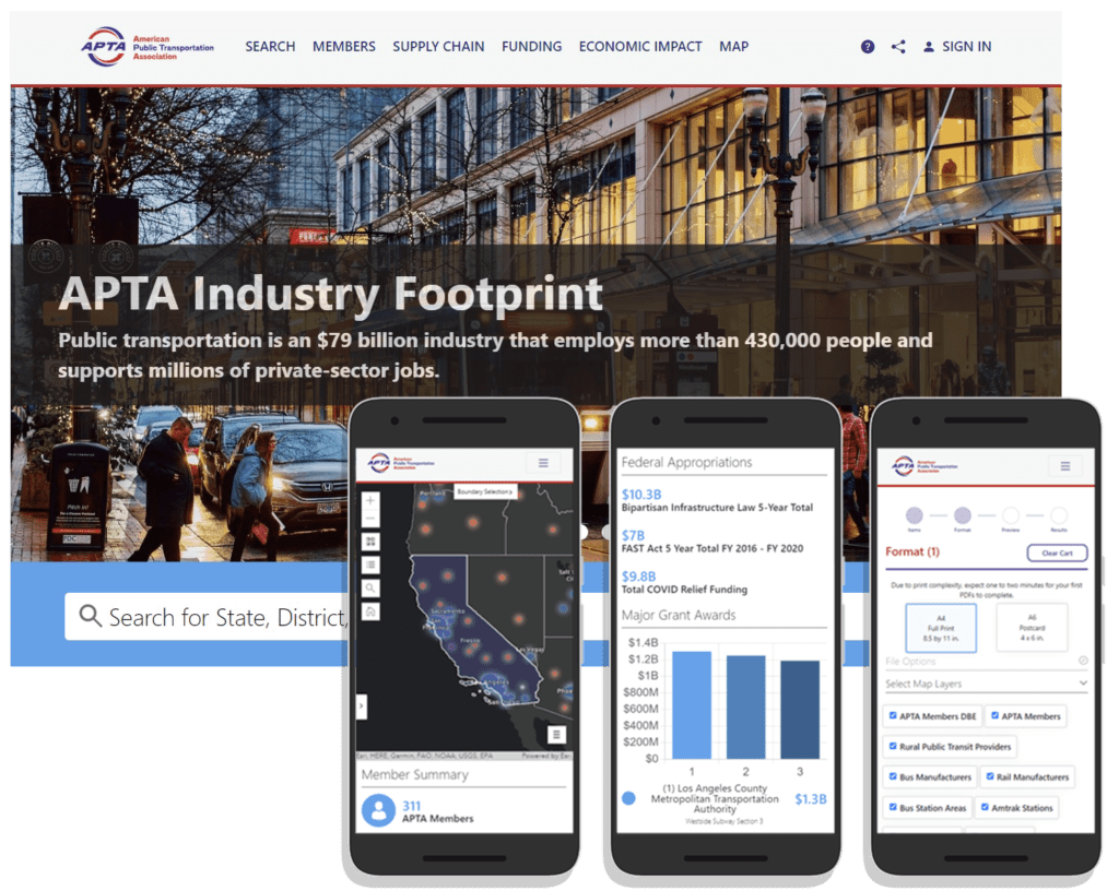
“We are happy with the results of our partnership with SymGEO. They produced a website that equals our ambition and stature as an association.”

– American Public Transportation Association, APTA Industry Footprint

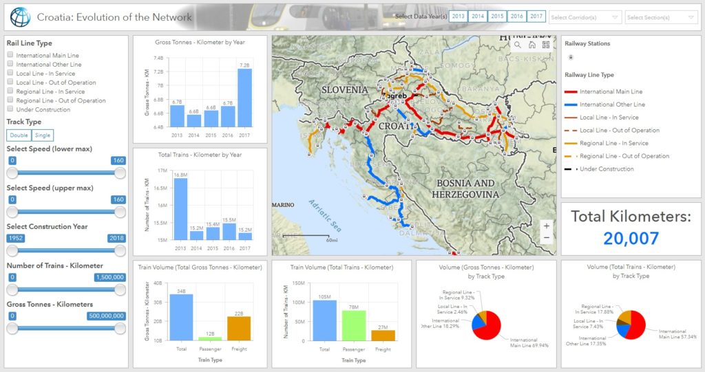
"This (mapping solution) is superb and exactly what the client needed and what I was imagining."

- The World Bank Group, Croatian Rail Dashboard

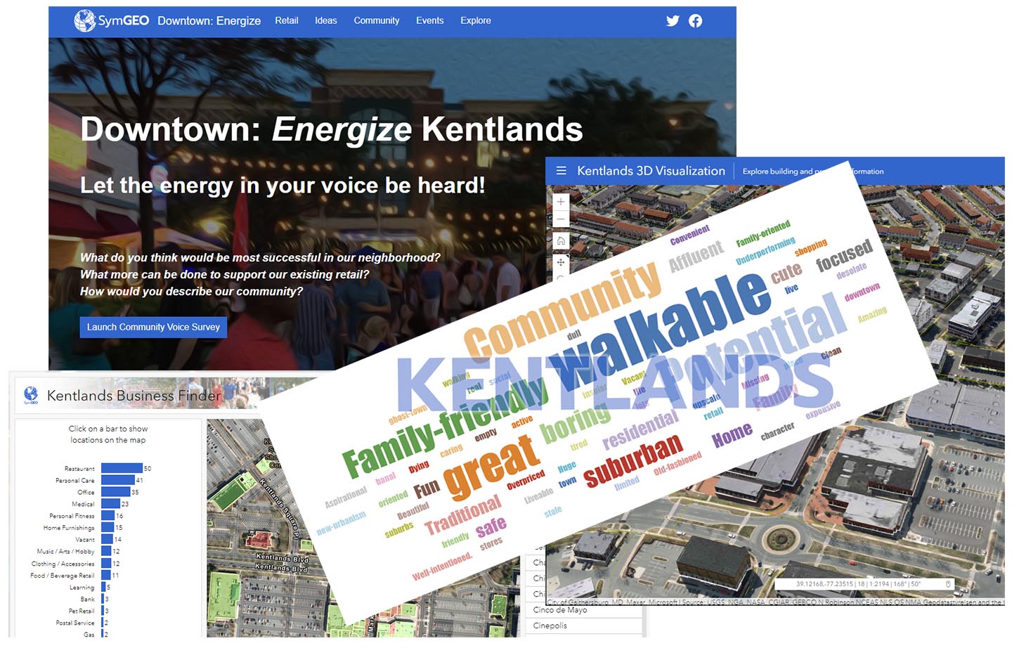
"Downtown Energize! is an innovative digital tool that is fun, easy to use, and flexible enough to accept updates and even track current events."

- Local Business Owner, Downtown Energize! Kentlands

Years of GIS Experience
Awards and Certifications
Satisfied Clients
%

Products and services

GIS MAPPING SOLUTIONS

SymGEO leverages configurable, data-driven technology from Esri to inform and communicate decisions.

COMMUNITY ENGAGEMENT

SymGEO designs and implements ArcGIS Hub and StoryMaps to educate, empower, and engage communities.

NONPROFIT ENABLEMENT

SymGEO configures GIS applications to track donor contributions, manage project assets, and communicate organizational success.

Vision Zero DC Hub site

Client: DDOT Vision Zero DC

Solution: SymGEO built a new Vision Zero DC website that provides a consolidated home for information on traffic safety projects, dashboards, and map features for an interactive user experience.

Capital Projects Dashboard

Client: DDOT Performance Office

Solution: SymGEO helped configure a Capital Projects Dashboard solution to visually communicate projects' budget and construction schedule status.

Downtown: Energize Kentlands

Client: Kentlands Downtown Working Group

Solution: SymGEO developed Downtown: Energize Kentlands to explore retail businesses and boost economic development through community engagement.

Croatia Rail Dashboard

Client: The World Bank

Solution: SymGEO developed a high-resolution, unified railway dataset and created a dashboard solution that improved data management and analysis.

Capital Projects Platform

Client: DDOT Performance Office

Solution: SymGEO built an interactive engagement portal called DDOT Capital Projects to communicate the status of DC's capital transportation projects.

DC Trail Rangers

Client: DC Trail Rangers

Solution: SymGEO configured and deployed an ArcGIS QuickCapture application for the DC Trail Ranger team to facilitate the data collection process.

GSU Academic Hub Site

Client: Governors State University College of Business

Solution: SymGEO built a pilot Data Explorer Hub site, available for students and faculty to explore and engage with Esri geospatial technology and the larger GIS community.

Capital Bikeshare Community Survey

Client: DDOT Capital Bikeshare

Solution: SymGEO built the Capital Bikeshare Station Request Tool to facilitate community feedback on proposed locations or to suggest new ones.

Ward7 Community Outreach

Client: Ward7 Outreach Committee

Solution: SymGEO built a community outreach site using ArcGIS Hub, designed to present a brief history of the area, a flavor of the neighborhood, the challenges faced due to a changing development landscape, and a call to action for the residents.

Urban Forestry Hub

Client: DDOT Urban Forestry Division

Solution: SymGEO built the Urban Forestry Division Hub site to engage and interact with the DC community and provide information about UFD services.

APTA Industry Footprint

Client: American Public Transportation Association (APTA)

Solution: SymGEO worked with our partners at GeoMarvel to develop the APTA Industry Footprint, designed to present public transportation data throughout the nation.

Special Event Operations

Client: DDOT Traffic Management Center

Solution: SymGEO configured and deployed an ArcGIS Special Event Operations Solution to enable the hosting of comprehensive information about an event in one authoritative, collaborative place.

DC Office of Zoning Handbook

Client: DC Office of Zoning

Solution: To facilitate the flow of technical information SymGEO designed and implemented the next-generation DC Zoning Handbook using ArcGIS Hub and ArcGIS Dashboards. Data is now referenced dynamically in a mobile-responsive format.

Urban Wood Reuse Program

Client: Urban Forestry Division of DDOT

Solution: SymGEO was excited to develop the community outreach component of the Urban Wood Reuse program by designing and launching the Wood Reuse Hub site using ArcGIS Hub and Survey123 technology

Ready to find out more?

Contact us to discuss your unique requirements and we'll build a solution together.

Esri, the Esri globe logo, ArcGIS, (etc) are trademarks, service marks, or registered marks of Esri in the United States, the European Community, or certain other jurisdictions. Other companies and products or Esri Trademark and Logo Guidelines services mentioned herein are trademarks, service marks, or registered marks of their respective mark owners. Trademark provided under license from Esri.