Capital Projects Dashboard

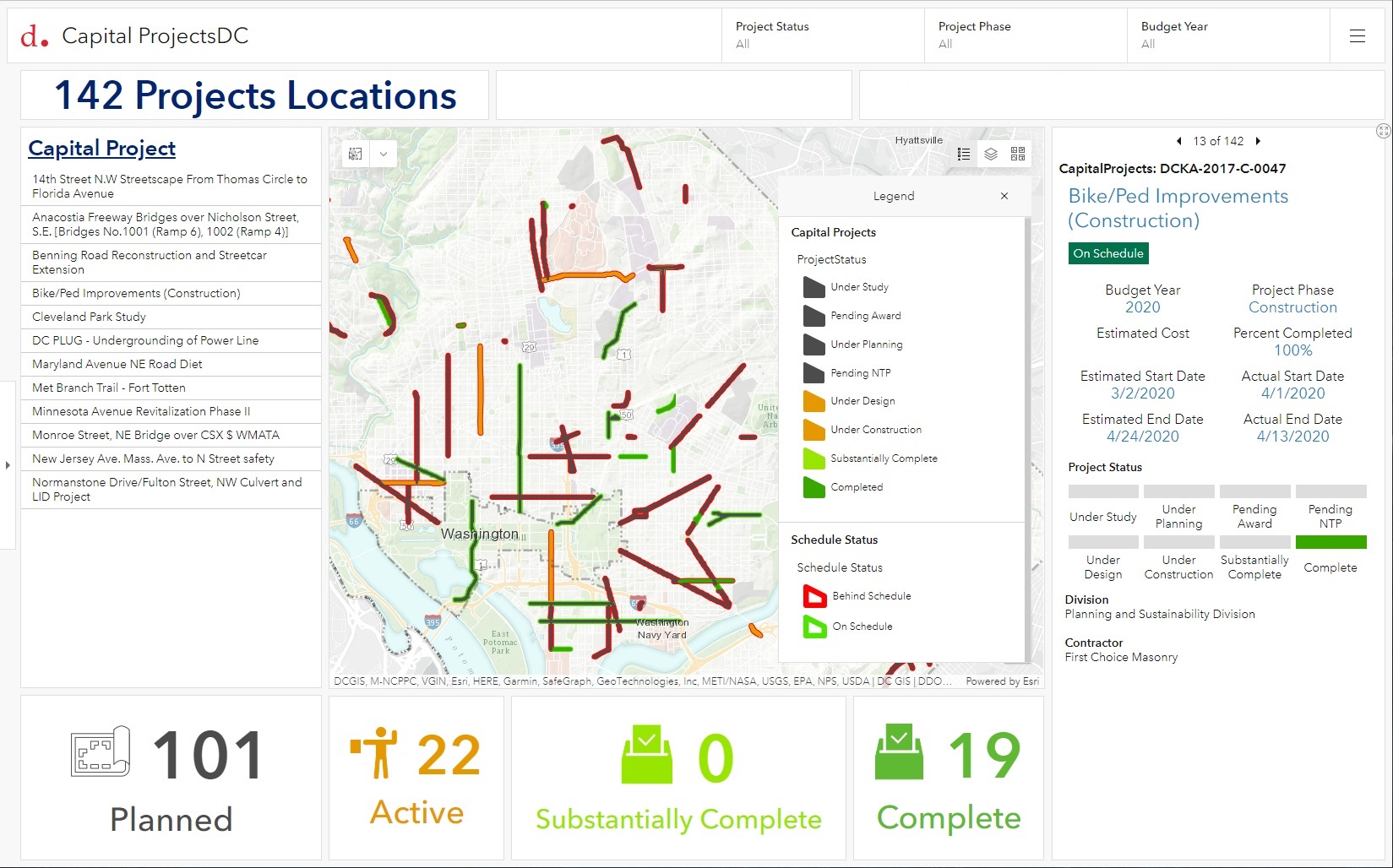
The District Department of Transportation (DDOT) manages millions of dollars’ worth of capital projects on an annual basis. To facilitate the communication of budget and schedule status, SymGEO helped configure a Capital Projects Dashboard solution for internal use, powered by ArcGIS Dashboards technology.

“This is so good! I love it and it is a game-changer. I am really impressed and could not be more thankful for this. This is a great tool for the agency to get things straight in the system and then use it as a tool for tracking.”

– DDOT Chief Performance Officer

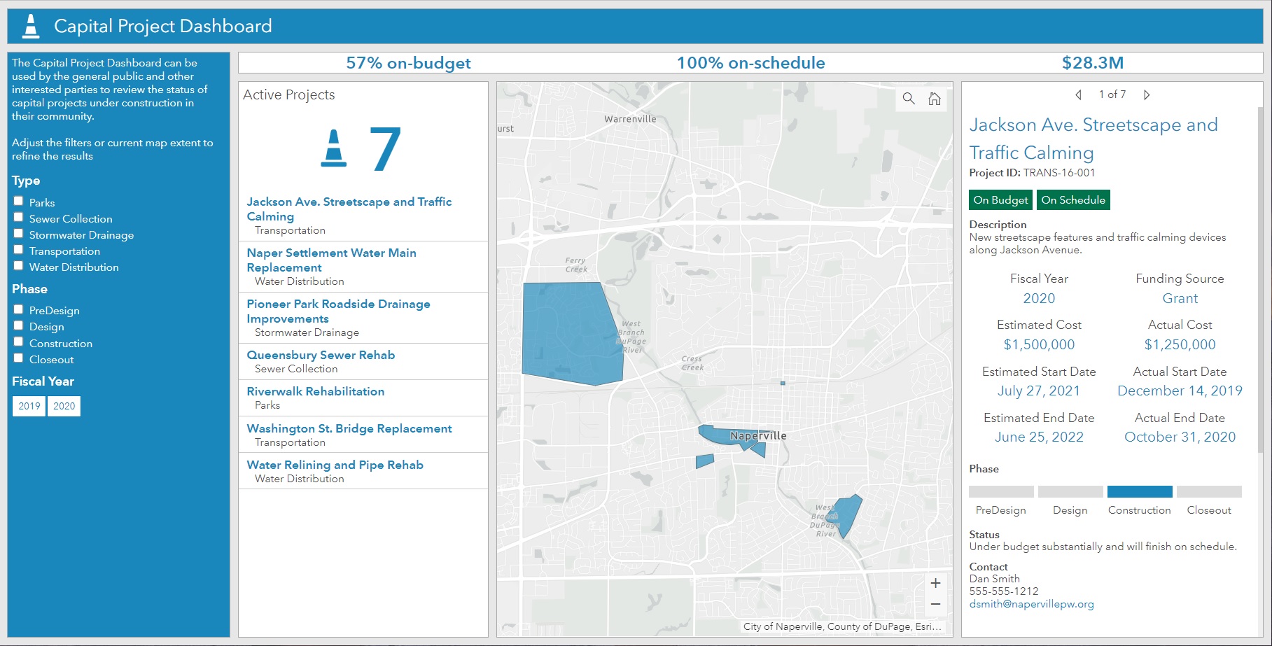
The configured solution builds on an Esri-provided template (below) and provides insight by budget year, construction status, and project phase. Summary statistics are provided as numerical indicators, and map symbology is used to visually communicate project status. The Arcade expressions, used to determine project status, were configured to fit DDOT’s capital project data schema using data provided by DDOT’s internal project management system.

capital projects dashboard template

Talk to SymGEO today if your agency or organization is interested in managing capital projects using the power of Esri’s Capital Project Dashboard solution – we are certified experts and here to help.

Arborist Workload Optimization

DDOT’s Urban Forestry Division (UFD) is the primary steward of Washington, D.C.’s ~175,000 public trees and has a mission of keeping this resource healthy, safe, and growing. At the front lines of this work is a team of almost twenty Urban Foresters who have district boundaries within which they provide tree services, inspections, special tree permit processing, and work order generation for tree planting, pruning, and removals as well as other daily responsibilities. As the tree canopy composition and jurisdictional boundaries change over time, workload optimization between arborists is key to keeping the process flowing smoothly. To help provide visibility into current workloads and explore proposed re-districting options, SymGEO worked with DDOT to build an Arborist Workload Dashboard using ArcGIS Dashboards technology.

The dashboard leverages Arcade expressions to aggregate workload components by arborist teams and proposed arborist boundaries, as well as display the proportional work per boundary sub-area.

Information is also aggregated to geographic boundaries, including Wards, Advisory Neighborhood Commissions (ANCs), and Single-member Districts (SMDs). Interactive charts allow exploration on a local, neighborhood-scale level as needed.

To facilitate the exploration and balancing of workloads, the final component of the dashboard allows interactive boundary area selection and workload summarization by individual components. With a balanced target in mind, the Supervisory Urban Forester can explore scenarios and then update the online information to reflect the preferred boundary scenario.

“This is really slick, thank you! I have already been editing in a webmap, and watching things balance out on the dashboard. Very cool, thank you again!”

-DDOT Supervisory Urban Forester

Talk to SymGEO industry experts today if your agency or organization is interested in leveraging ArcGIS Dashboards to re-district boundaries and optimize workloads – we are certified experts and here to help.

Tree Preservation

Did you know that trees are so important to Washington DC that they are protected by the Urban Forest Preservation Act and the Tree Canopy Protection Act? This means that before performing any excavation or construction activity on private property, it is important to consider any potential impacts to the trees on site. To facilitate this process, SymGEO is proud to help DDOT launch a new resource, the Tree Preservation Hub site, for property owners and construction companies to identify which trees need to be protected and how to best take care of them during home renovations or new construction projects.

tree preservation hub site

Built using ArcGIS Hub technology, this site leverages ArcGIS Online mapping and graphic examples to help explain what type of permit or protection plan is needed based on estimated tree size. Tree sizes were estimated using LiDAR processing, which in turn is used to estimate the critical root zone and structural root zones that need to be protected during construction. Modeling several hundred thousand trees at the same time has its challenges; however, ArcGIS Pro, ArcGIS Enterprise, Arcade expressions, and hosted image services were used to efficiently capture and share the modeling results.

Talk to our industry experts today if your agency or organization is interested in community engagement with the power of Esri’s ArcGIS Hub or data processing with ArcGIS Pro – SymGEO is here to help!