ArcGIS Hub-Ready

The world is awash with data and mapping applications, so how does one go about organizing them into meaningful, searchable components? Esri’s new ArcGIS Hub initiative is designed to organize people, processes, and technology to meet those needs. This technology gives context and purpose to data, and provides an excellent two-way engagement platform to connect departments and stakeholders.

Using this mobile-responsive framework, SymGEO has built our own SymGEO Hub, and populated it with examples and branding from our main website.

If your organization is ready to get started with ArcGIS Hub, SymGEO is here to help!

Data Collection

Specialized data sets that answer a focused need can be difficult or impossible to find, and sometimes the data set you need simply doesn’t exist. Maybe you need locations showing the availability of fresh food in your neighborhood, or want to know the location and condition of utility boxes, or the occurrence of garage sales. Fortunately, a number of configurable data collection products are available from Esri to help.

The first question to answer is: will you be able to tap into crowd-sourced power to populate the data set? If so, a publicly accessible web link is the way to go. Esri has introduced GeoForms and Survey 123, which allow any user to enter in the attribute information and location of the data when set to public. Alternatively, the permissions can be set so that just a specific group or user within your organization can access the forms.

These configurable applications are mobile responsive, so fit very well onto a phone, where you can leverage the on-board camera to collect pictures at the same time.

Another branch of data collection technology is Collector, which allows both connected and disconnected editing by named users. This may be useful in environments without access to mobile data or wi-fi, such as those following a disaster or storm event. These native applications are available for Android, iOS and Windows, and sync to data stored in ArcGIS Online or within an enterprise GIS when back in a connected environment.

If you’d like some help getting set up for mobile data collection, SymGEO is here to find you the perfect fit!

Workflow Automation

I admit, I resisted for years. Workflow automation seemed like too much work to set up, and I always argued that my spatial data challenges were mostly one-off unique situations that weren’t conducive to setting up a workflow. Until one recent day I saw the light… and I blame California.

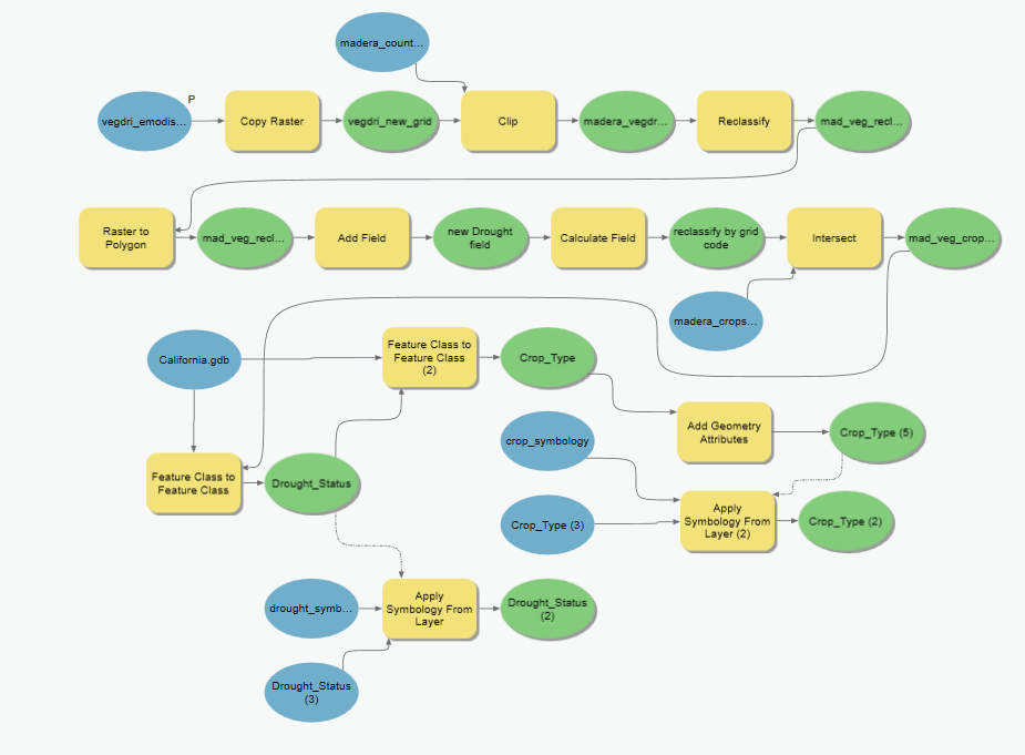
Perhaps you remember our work to incorporate near real-time remote sensing into crop drought monitoring? Well, it turns out that to keep an application like that up to date, the same process is needed time and again, and so the need for data automation was born into the world of SymGEO. Through automation, data layers and attribute fields are always named the same, and features can be over-written without fear of “something breaking” deep within a configurable application. There is also the added benefit of incorporating the usual workarounds that go into regular behind-the-scenes geospatial work such as calculating areas as acreage, or converting grid values into meaningful text. This saves countless hours of frustration and memory searching down the road when trying to repeat a process.

Needless to say, this does cause a model to expand once all the pieces are bolted on, but Esri’s ModelBuilder allows the easy configuration (and re-configuration) of the model until all works as designed.

workflow automation

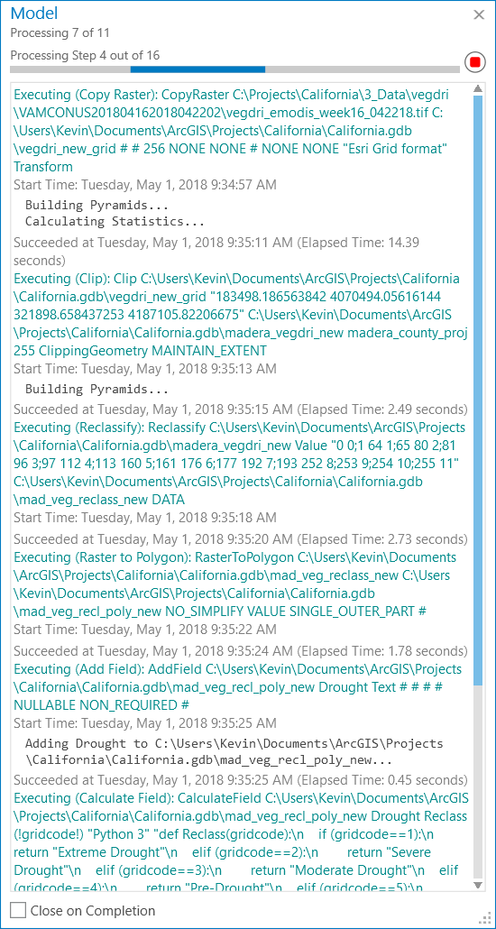
This model has been run many times to make sure all products worked as expected, especially during initial configuration. However, the time savings was considerable with workflow automation given the number of steps involved and the dependency on intermediate layers. In hindsight, it seems to be the finding and configuring of the tools that takes time, not the actual running of the tool.

model processing

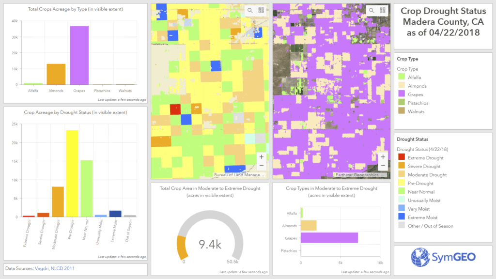
These work products were used to produce and optimize the Crop Drought Status dashboard, which is now ultra-responsive and designed for use at the county-level.

crop drought status dashboard

If you’d like a second pair of eyes on your data workflow, let us know, as SymGEO is ready to automate with ModelBuilder!

April News 2018

Spring has sprung, and new ideas are growing left, right and center! This month SymGEO has focused on the 3D building construction process, from local buildings to city-wide development, and dove into mobile workforce management. Follow us on Twitter or LinkedIn for timely news, and let us know if you’d like to see specifics on any technology mentioned here.

building a digital city
We have continued to improve upon our process for building 3D models, and scaled up production to the city level. Using LiDAR data and building footprints, digital city twinning facilitates planning and redevelopment scenarios.

Read more


When generic building textures aren’t enough, we use ground-level photography as a “skin” for the building. This makes the buildings instantly recognizable to audiences familiar with the locations.

Read more


workforce management

So, your people are your greatest asset. Do you know where your greatest assets are? Right now?? Mobile workforce management just got a lot easier with Esri technology.

Read more


project page

Check out these projects (and their friends) on our newly updated projects page, and let us know if you have a pet project that could use some SymGEO love.