From Historic Maps to Community Events: Bringing Bethlehem’s Annual Yard Sale Online
Turning a community yard sale into an interactive, map-based experience with Survey123 and ArcGIS Dashboards
The Bethlehem Historic District Association (BHDA) has been using its growing collection of interactive mapping tools to help residents and visitors explore the history, architecture, and culture of Historic Bethlehem. But the same GIS technology that helps tell the story of Bethlehem’s past can also bring the community together today.
For BHDA’s annual community yard sale, SymGEO helped transform a traditional neighborhood event into an interactive, map-based experience that makes it easier for participants to advertise their sales – and easier for shoppers to find them.
From Yard Sale Listings to an Interactive Map
The project began with a simple goal: provide residents with an easy way to submit their yard sale information while creating a centralized resource where visitors could see what was available throughout the district.
SymGEO configured a public ArcGIS Survey123 application that allowed residents to submit their yard sale locations and information directly from their phones or computers. The survey collected the details shoppers would want to know before heading out, including:
- Yard sale location
- Categories of items available
- Descriptions of items for sale
- Photos
- Special instructions or location details
That last piece can be particularly helpful for neighborhood sales. Sellers could provide directions such as “items are located in the garage behind the house,” helping visitors know exactly where to go once they arrived.
A Simple Approval Process Keeps the Map Current
Because submissions were coming directly from the public, BHDA also needed a way to review the information before it appeared on the public-facing map.
SymGEO configured an approval process that allows the yard sale administrator to review incoming submissions and approve them before they are made public. This provides BHDA with an important layer of quality control while allowing the organization to manage the event without having to manually rebuild or update the map.
Once approved, the submissions become part of the interactive yard sale map.
An Interactive Map Built for Exploring
The approved yard sales were brought together in an ArcGIS Dashboards application designed specifically for the event.
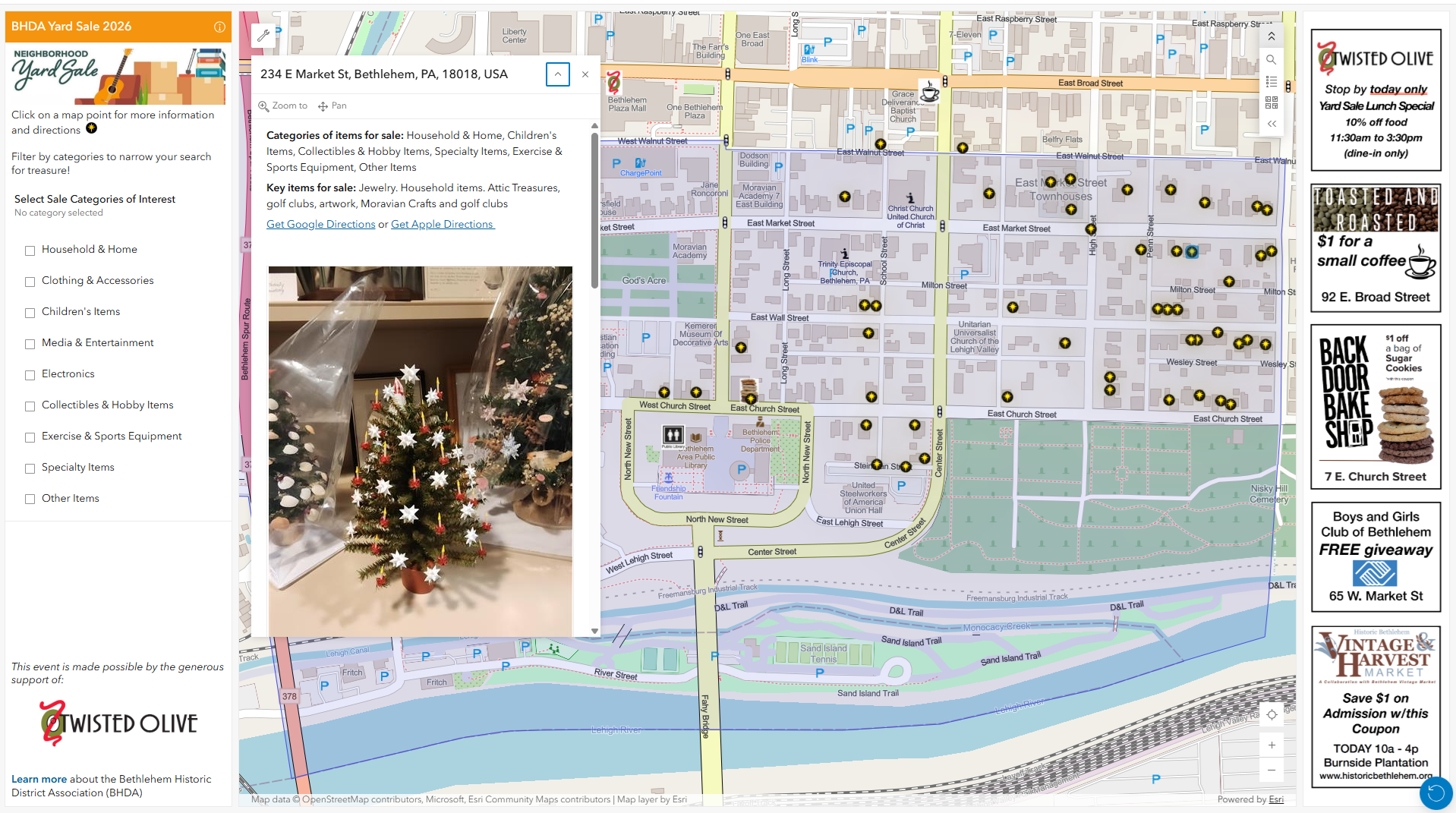
Rather than simply displaying a collection of points on a map, the dashboard allows visitors to explore the sales based on what they are looking for. Shoppers can filter the map by categories of items for sale, making it easier to find the types of goods they are interested in.
Clicking on an individual yard sale opens a detailed pop-up with additional information, including photos, descriptions, and special instructions from the seller.
The map also provides direct links for navigation, allowing users to open Google Maps or Apple Maps directions from the yard sale location. This turns the dashboard into more than an event directory – it becomes a practical tool for planning a day of shopping throughout the historic district.
Supporting Local Businesses Along the Way
The yard sale experience also provides an opportunity to highlight participating local businesses.
BHDA incorporated business coupons and special offers into the dashboard, giving visitors another reason to explore the surrounding community while attending the yard sale. In this way, the map connects individual yard sale locations with the broader local business community.
For an event that is inherently neighborhood-focused, this creates a natural connection between residents, visitors, sellers, and local businesses.
Connecting the Printed Map to the Digital Experience
While the interactive dashboard provides a rich digital experience, BHDA also recognized the value of a traditional printed map.
BHDA staff created a printable version of the yard sale map that was distributed to participants and visitors. A QR code on the printed map provided a direct connection to the interactive dashboard, allowing users to move seamlessly between the physical and digital experiences.
Visitors can start with the printed map, scan the QR code with their phone, and then access the latest information, filters, photos, directions, and other details through the interactive application.
Building on a Growing Community GIS Platform
The yard sale project builds naturally on the work SymGEO and BHDA began with the Bethlehem Historic District Explorer.
What started as a way to digitally document and share Bethlehem’s historic properties has grown into a flexible GIS resource for community engagement. The same underlying GIS capabilities can support a variety of applications – from historic preservation and cultural storytelling to community events and local business promotion.
The yard sale application demonstrates how existing GIS technology can be adapted to meet a completely different community need. Rather than creating a static event map that has to be manually maintained, BHDA now has a workflow that allows information to be collected from the community, reviewed by staff, and published through an interactive map.
Putting the Community on the Map
The annual yard sale may be a relatively short-lived event, but the technology behind it demonstrates a much broader opportunity.
By combining ArcGIS Survey123 and ArcGIS Dashboards with thoughtful data collection, review, mapping, and print design, BHDA created a resource that brings together community-submitted information, interactive mapping, local business promotion, navigation, and traditional print materials in a single experience.
The result is a resource that makes the yard sale easier to participate in, easier to navigate, and more connected to the surrounding community.
And perhaps most importantly, it puts the community itself on the map.
“The yard sale project is a great example of how our partnership with SymGEO has continued to evolve. We started by using GIS to tell the story of Bethlehem’s historic properties, and we are now using those same tools to engage the community in new and creative ways. It definitely demonstrates how Bethlehem’s past resonates to bring the community together today.”
– Bethlehem Historic District Association
Talk to SymGEO today if your organization would like to organize community events using the power of Esri’s ArcGIS Online platform – we are certified experts and here to help.