Greensboro’s Tree Canopy Assessment & Planting Hub

SymGEO is proud to announce the launch of the City of Greensboro’s Tree Canopy Assessment and Priority Planting Program hub site!

This platform is the result of a collaborative effort between Planning Communities (project lead), SymGEO, Breece Robertson Consulting, and the Office of Sustainability and Resilience for the City of Greensboro, NC. The hub is designed to guide strategic tree planting and stewardship efforts, while also supporting community engagement, education, and policy and program recommendations to grow and protect Greensboro’s tree canopy.

Built on Esri’s ArcGIS Hub technology, the site leverages ArcGIS StoryMaps, Dashboards, and Survey123 to create an interactive experience for residents and tree-planting partners, making it easier than ever to explore Greensboro’s urban forest and get involved.

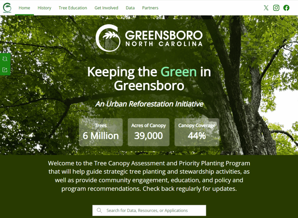
The hub features quick facts and figures about the tree canopy and its benefits, along with other reports and future plans for the City’s urban forest.

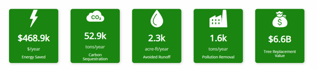
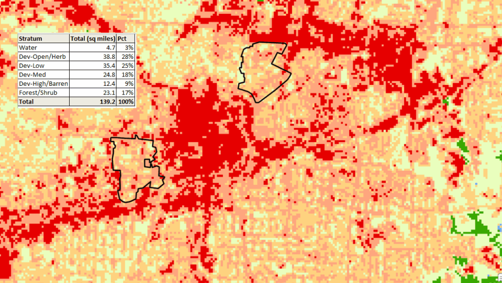
SymGEO led Greensboro’s tree canopy assessment by combining advanced spatial data processing, statistical analysis, and environmental benefit modeling. Using Deep Learning in ArcGIS Pro, high-resolution imagery was classified into distinct land cover types and paired with National Land Cover Data to build a detailed picture of the city’s landscape. Insights from 5,000+ sampled trees were expanded citywide using Forest Inventory Analysis methods, providing a statistically reliable estimate of tree canopy conditions across Greensboro. These results were then processed through i-Tree Eco tools to calculate the environmental benefits that trees provide—such as cleaner air, stormwater management, energy savings, and improved quality of life. This assessment equips city leaders and residents with valuable information to guide urban forestry decisions, prioritize tree planting, and maximize the community benefits of Greensboro’s urban canopy.

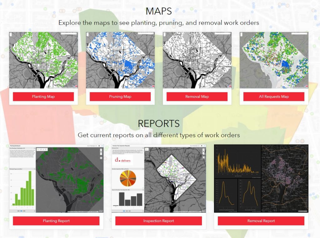
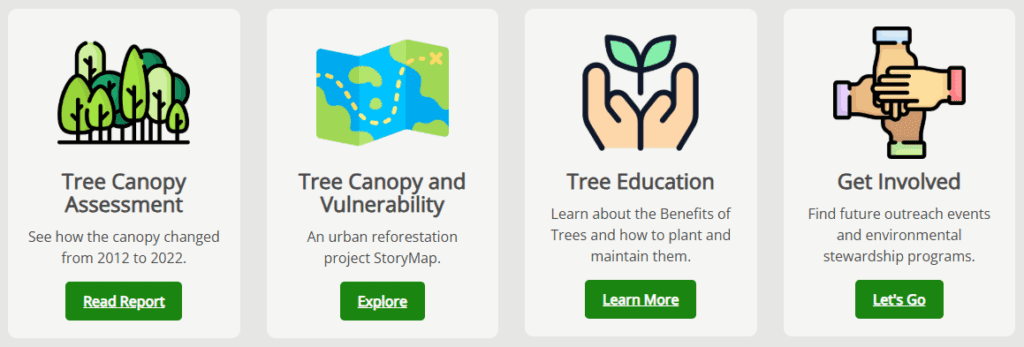
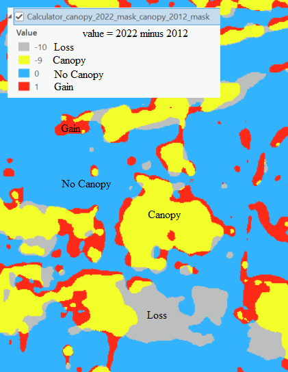
The Deep Learning classification method was repeated using historic imagery and then compared to current results to show areas of canopy loss, gains, and future planting opportunities (potential planting areas).

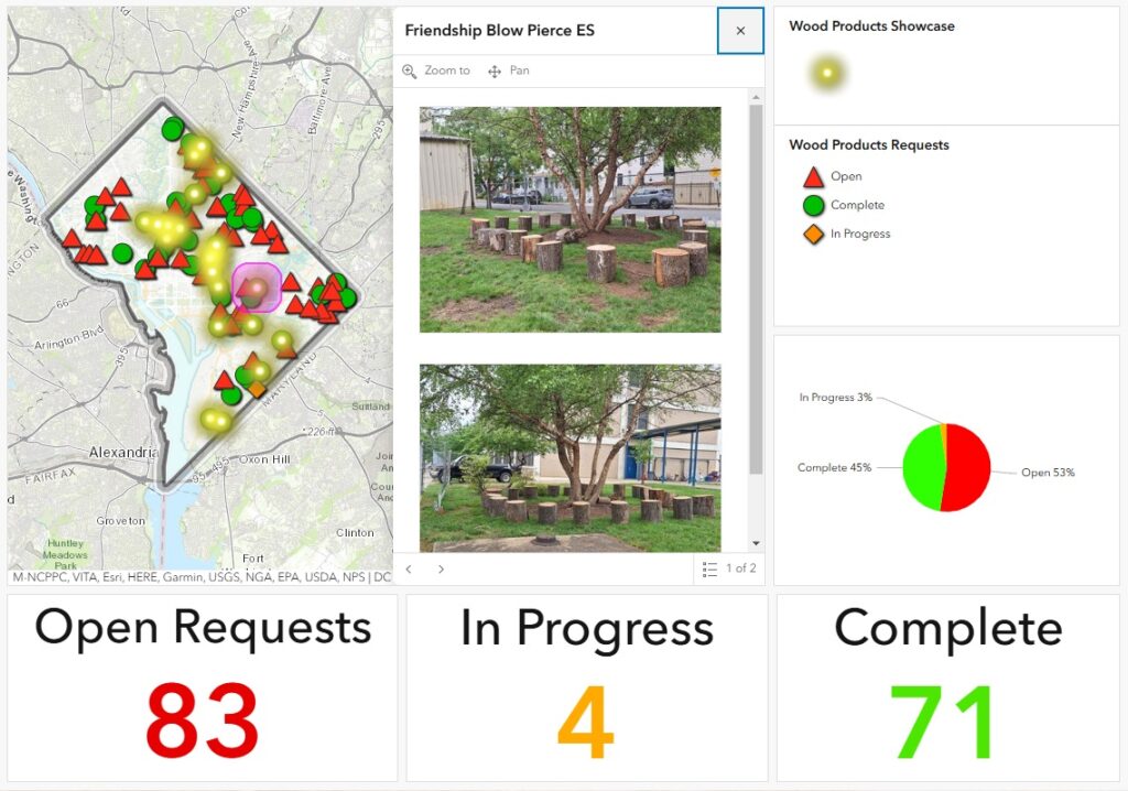
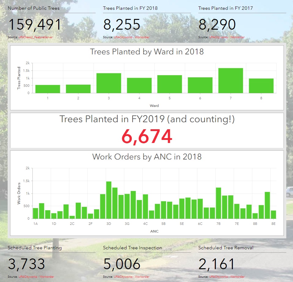
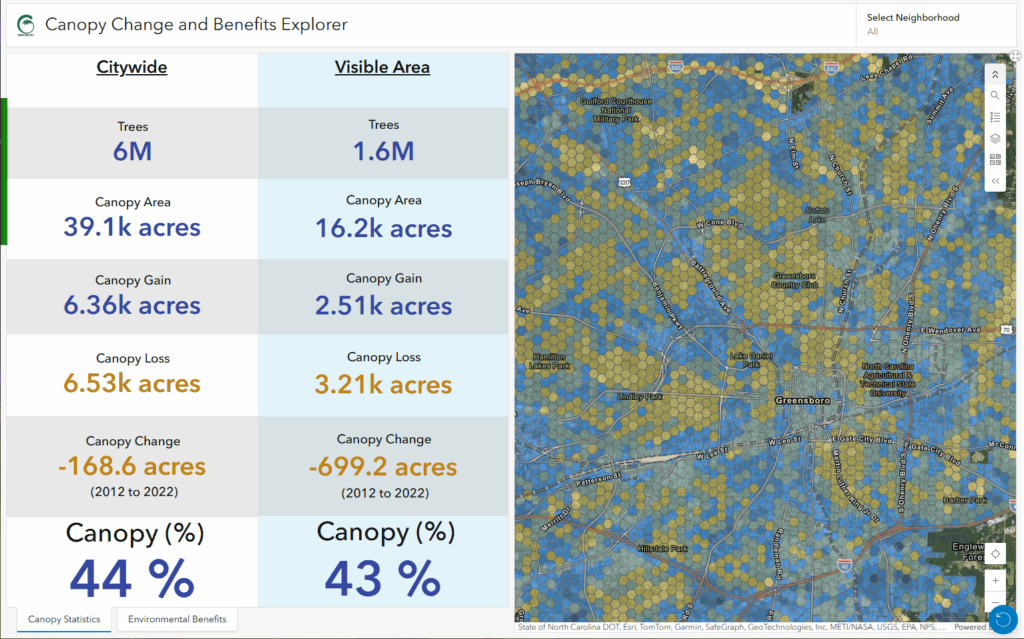
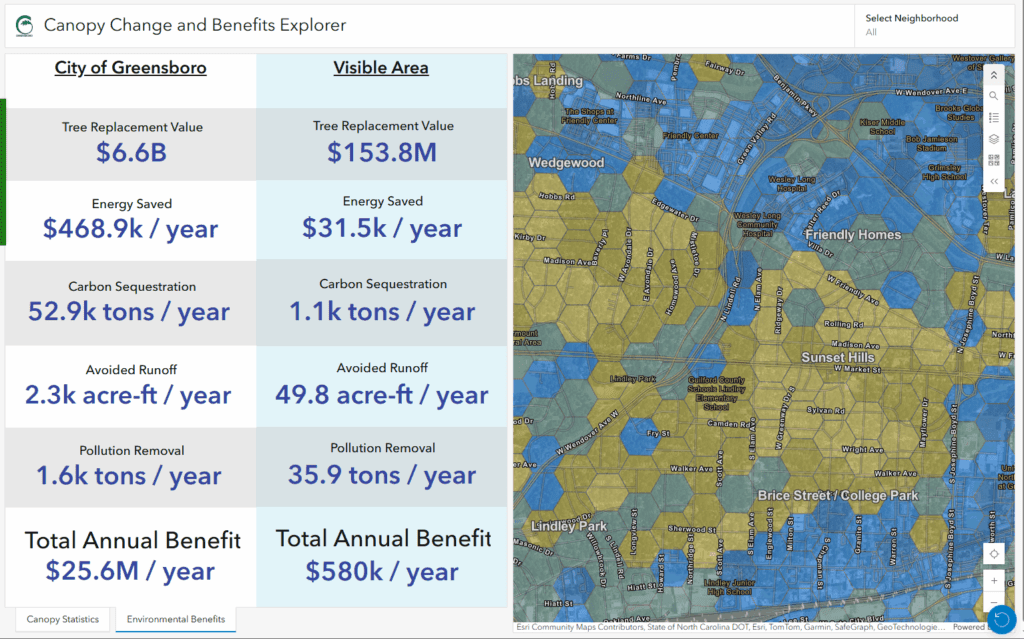
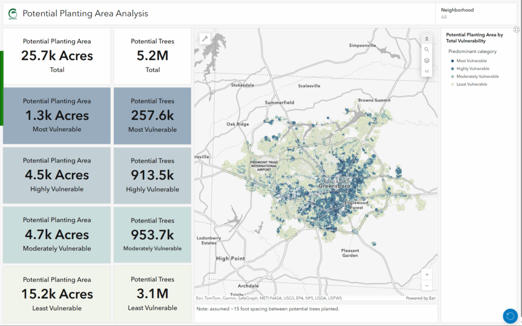
Canopy statistics were summarized in a dashboard featuring both canopy changes and environmental benefits.

The results of the canopy assessment were combined with a detailed vulnerability assessment performed by Planning Communities and summarized in an interactive dashboard that shows where planted trees would provide the greatest benefit.

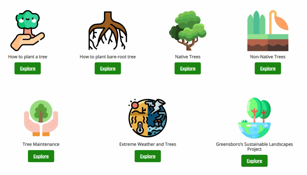
The hub site also features a resource section that facilitates the exploration of best practices regarding planting, maintaining, and planning for future trees.

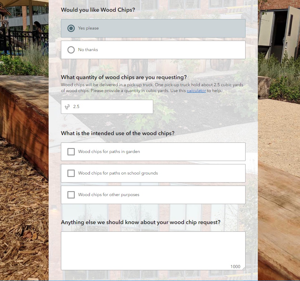
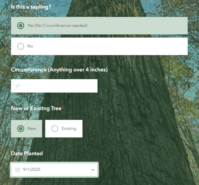
A survey to capture new trees planted by residents was built using Survey123 and encourages 2-way stakeholder engagement.

“The hub is an amazing visualization of multiple data points and information uniting on one platform – solidifying a need for continuous growth in Greensboro, one tree at a time!”

– Shree Dorestant, Chief Sustainability Officer, City of Greensboro NC 


“Creating a place for the citizens to interact with their data in a useful way was a high priority for this project. Every Hub element and dashboard was designed to get the residents to understand how the canopy impacts their house, their neighborhood, and the city as a whole.”

– John Hendricks, GIS Analyst, City of Greensboro NC 

Talk to our industry experts if your agency or organization is interested in conducting a canopy assessment or leveraging the power of Esri’s ArcGIS Online and analytical technology – SymGEO is here to help!

One Main Street Initiative

SymGEO is pleased to launch the One Main Street Initiative website produced in collaboration with our local commercial development volunteer committee. This website is powered by ArcGIS Hub technology and is designed to engage business owners and residents in the transformation of the Main Street of Kentlands into a vibrant, family-friendly, retail destination. This was accomplished by summarizing the key findings of a detailed local study conducted by Live Work Learn Play that charted a path forward to energize the Main street through a combination of events, physical improvements, dedicated leadership, and community involvement.

Each key component of the study was summarized and shared using a combination of text and graphics to facilitate community understanding, discussion, and evaluation.

After presenting the key findings, ArcGIS Survey123 was used to gauge public reaction to the importance of each component.

Finally, ArcGIS Dashboards was leveraged to create and share a helpful Main Street Explorer tool (desktop or mobile) for residents to see which businesses are already on Main street and where opportunities for new businesses are located.

Talk to our industry experts today if your community is interested in harnessing the power of Esri’s ArcGIS Hub to share and amplify your development plans – SymGEO is here to help!

School Recycling: Urban Wood Reuse

Teaching kids the importance of nature, recycling, history, and culture is a lofty goal. Perhaps it’s a lesson that could be taught from the comfort of a bench constructed from recycled urban wood sourced from a local DC neighborhood rich in cultural history? This is now possible thanks to the District Department of Transportation (DDOT) Urban Forestry Division (UFD)’s new initiative called “Urban Wood Reuse: for Schools“. This partnership with the Office of the State Superintendent of Education (OSSE) will provide DC Public Schools and public charter schools with wood products to improve school grounds at no cost.

SymGEO was excited to help the Urban Forestry Division (UFD) develop this initiative by using Esri’s ArcGIS Hub technology to establish two-way communication between the UFD and DC schools interested in “sitting on a piece of DC History”. The site shares knowledge and products from the UFD while gathering the school’s product ideas and requirements.

The site discusses the benefits of wood reuse, where the wood comes from, and the variety of products available including benches, stumps, or woodchips. It also provides a link to an order form as a convenient and easy way to request wood products.

The order form itself is powered by Esri’s Survey 123 for ArcGIS technology and is designed with step-logic where pertinent questions appear based on previous answers.

One of the exciting new aspects of an initiative is the ability for an audience member to sign into a community account and “follow” the initiative. This will grant them access to broadcasts about new events, updates, new product launches, and other useful information. Now, being able to show which schools are as excited as we are about this new initiative has never been easier!

Talk to our digital platform experts today if your agency or organization is interested in community engagement with the power of Esri ArcGIS Hub Initiatives – SymGEO is here to help!

Downtown: Energize! in ArcNews

SymGEO was honored to have our community engagement pilot project Downtown: Energize! Kentlands featured in the 2019 ArcNews Spring edition!  This premier hard-copy and digital publication by Esri has a circulation of 900,000 industry professionals and is a go-to source for all that is new and innovative in the Esri GIS community.

This wonderfully in-depth article examines the purpose and need of the site, the benefits brought to residents and businesses, and of course, the amazing Esri technology that makes it all possible.

Check it out, and let us know if your community would like to experience the positive power of Downtown: Energize!

DDOT Urban Forestry Division Hub

SymGEO is pleased to announce the launch of the DDOT Urban Forestry Division Hub! This new digital platform is designed to engage and interact with the DC community and provide information about the many services and resources offered by the Urban Forestry Division (UFD) of the District Department of Transportation (DDOT). This digital platform was built using Esri’s ArcGIS Hub technology, in coordination with OCTO and Open Data DC.

With a long history of caring for the extensive forest canopy in DC, the Urban Forestry Division has meticulously assembled data sets and applications to help in their forest management mission and to communicate with a variety of audiences. With the introduction of Esri’s ArcGIS Hub technology, there is finally a digital platform perfectly designed to tie all the pieces together into a cohesive story. SymGEO was honored to be approached by the Urban Forestry group to help them design, configure, and deploy this comprehensive digital solution.

“SymGEO is a remarkably flexible and responsive company. They listen carefully to requirements and deftly blend customer vision with technological capabilities.”

DDOT Associate Director / State Forester, Urban Forestry Division

The urban forest story begins with a look to the past and introduces the audience to the long history and important role of trees in DC.

history

The story then turns to the impressive variety of trees available for public enjoyment and leverages several applications and digital stories that the urban forestry group has already developed.

canopy

The flagship data set of the Urban Forest group is the Public Tree Map which elegantly displays a tremendous amount of current information about the urban tree canopy. Links are provided to both the map and the underlying data for the community to use and explore.

public tree map

Work orders, permits, inspections, plantings, removals… there’s a lot going on in Urban Forestry! Fortunately, many data sets and reporting mechanisms have been developed to keep track of it all. These have now been shared with the public under one digital roof for a better understanding of agency scope and status.

urban forestry maps

Of course, what fun are statistics if they can’t be updated on the fly as new information is entered into databases behind the scenes?

stats

Finally, links to tools and resources are provided for partners and stakeholders to begin making their own applications and discoveries with DC government data.

tools

Talk to our industry experts if your agency or organization is interested in leveraging the power of Esri’s ArcGIS Hub – SymGEO is here to help!

SymGEO Hub in the News

This month we were honored to have Downtown: Energize! featured in two local papers. There has been tremendous energy and enthusiasm swirling around this flagship project from SymGEO, and the technology continues to improve with every update.

lakelands newspaper

Downtown: Energize! features many different components of the ArcGIS technology suite, including Survey123, GeoForm / Collector, ArcGIS Dashboard, Web AppBuilder for the retail locator, and a web scene that uses CityEngine textured models derived from building footprints and Lidar information processed in ArcGIS Pro. These components are then hosted in ArcGIS Online and leveraged using ArcGIS Hub technology.

downtown energize banner

Two local development boards, the Kentlands Downtown Working Group (KDWG) and the One Main Street Initiative (OMSI), took an excited interest in Downtown: Energize! and have commissioned complimentary sites to be built using Hub technology. The commercial real-estate management of the site is especially useful in a fast-paced environment!

kentlands newspaper

“The KDWG was commissioned by the Kentlands board to provide accurate and timely information on the various development efforts going on with our downtown so residents can be better informed and take a more active role in improving our community. We chose the Downtown: Energize! platform developed by SymGEO with its innovative digital mapping because it helps do exactly that.”

– John Ingrassia, Chair, Kentlands Downtown Working Group

“A great commercial district is a huge amenity for our community. Downtown: Energize! is a great digital tool for helping the community achieve the vision for our commercial district. Not only will it help us engage the community to provide flexible two-way dialogue, but it will help us by mapping opportunities where businesses can expand and thrive. This innovative platform will allow us to easily update data, access data and provide data well beyond our community, which provides outreach to businesses looking to expand. Additionally, it is a fun way to empower consumers looking for a place to spend their precious free time to engage with this easy to use tool whether at home or mobile. Working with Kevin at SymGEO has been an amazing experience. He and his team are bringing tremendous innovations and ideas to our team at The One Mainstreet Initiative.”

– Neil Burka, Chair, One Main Street Initiative

“I was so excited when SymGEO came to us with this idea. As a local real estate agent and resident who is deeply engaged in the community, I understand on a personal level how important this spatial data is to get the community engaged and onboard with what’s happening. This platform will make it easy to access the data – especially for folks who, like me, are more visual.”

– Sheena Saydam, Realtor, Keller Williams Capital Properties, Member, Kentlands Downtown Working Group

“Downtown: Energize! as created by Kevin McMaster using the SymGEO platform, is an innovative digital tool that provides mapping of business locations to potential and existing customers in a format that is fun, easy to use, and flexible enough to accept updates and even track current events. It’s a win-win for our community by empowering residents to engage with our local businesses and to energize our downtown!”

– Ingrid L. Fraley, Local Business Owner – Design Services, Inc.

kentlands 3d

If you’d like to join the party with a Downtown: Energize! initiative, let us know as SymGEO is here to help!

Commercial Property Management

Keeping track of who is where, what’s coming soon, square footage available, and when leases are ending can be quite a challenge when hundreds (or thousands!) of properties are involved. Fortunately, GIS is perfectly suited to this task of commercial property management, as it combines space, time, attributes and symbology into one cohesive picture.

For the Kentlands community in Gaithersburg, MD, ArcGIS Online data was used to power an initiative called Downtown: Energize!, that has garnered critical acclaim from residents and business owners alike. This Hub site designed to explore existing retail, gather community ideas, and identify opportunities for commercial business. With almost a hundred commercial properties involved, including several large commercial parcels, the data came in the usual assortment of formats (pdf, GIS, field collection). However, the end result was a cohesive framework designed to be updated and informed by the community it serves through a crowd-sourced GeoForm application.

data updater

geoform

Searching by business name was enabled through a configurable application that is embedded into the Hub site. There is also active development and building reconfiguration occurring in this area, as shown below with the current buildings overlaid on last year’s imagery. This solution provides a one-stop shop for information about current commercial businesses in the area, and a common platform for the community to use.

If your community is ready to get started with a Downtown: Energize! initiative or your business would like to use GIS as a property management tool, let us know as SymGEO is here to help!

Downtown: Energize!

Community engagement and business development are key ingredients for a successful neighborhood. Rapid advancements in web technology have made it easier than ever to engage with your citizens and neighbors and to create a real sense of ownership and responsibility for the direction of the community. To facilitate community engagement from a retail business perspective, SymGEO created Downtown: Energize! using ArcGIS Hub technology.

The site was well-received by residents and business owners, has been featured in several local newspaper publications, and in Esri’s ArcNews publication entitled “ArcGIS Hub Gets Mixed-Use Community Involved in Retail Decision-Making“. It also showcases a commercial real-estate management system designed to keep track of existing businesses, future businesses, and available locations.

Downtown: Energize! includes:

  • An idea section for the community to voice what type of retail they would like to see, powered by Survey123.


  • Word-clouds generated from community surveys into the types of retail that are needed

  • An opportunity locator section to highlight available commercial properties, powered by GeoForms and Web AppBuilder 

  • A look at existing retail in the neighborhood

cornerstone retail

  • Lots of great neighborhood-specific data from Esri

3d energize

  • Links to upcoming neighborhood events to show local activities

community events

Everything is fully mobile responsive using modern Esri web architecture, ensuring community access and interactivity on the go.

If your community is ready to get started with Downtown: Energize!, let SymGEO know as we are here to help.

ArcGIS Hub-Ready

The world is awash with data and mapping applications, so how does one go about organizing them into meaningful, searchable components? Esri’s new ArcGIS Hub initiative is designed to organize people, processes, and technology to meet those needs. This technology gives context and purpose to data, and provides an excellent two-way engagement platform to connect departments and stakeholders.

Using this mobile-responsive framework, SymGEO has built our own SymGEO Hub, and populated it with examples and branding from our main website.

If your organization is ready to get started with ArcGIS Hub, SymGEO is here to help!