Flood Impact Visualization

SymGEO is excited to demonstrate flood visualization technology built on the Esri Local Government 3D Basemap Solution.  In this example, the City of Laurel, Maryland, has a number of buildings that are located in the floodplain and are therefore at risk of flooding. This information can be conveyed using the FEMA National Flood Hazard Layer (NFHL) Viewer as shown below, but we decided to bring this data to life using an Esri ArcGIS Solution instead!

Our journey began with a virtual trip to the Maryland iMap GIS data portal to download the best-available LiDAR data for our area of interest. We then visited the Maryland-National Capital Park and Planning Commission GIS Open Data portal to get building footprint information. Finally, after following the defined steps in the ArcGIS Local Government Solution, we were able to visualize flood impacts in realistic 3D from citywide to local perspectives.

Realistic building textures, vegetation, and current imagery allow the user audience to recognize features and landmarks during demonstrations. Streets can be labeled, and buildings of interest can be highlighted with either labels or colors to call attention to focus areas.

Continual improvements using Esri’s 3D rendering and animation technology enable fly-throughs, call-outs, layer transitions, time-lapse visualizations, and other features and functionality that make this 3D basemap solution the perfect tool to communicate risk and mitigation plans.

Contact SymGEO for your 3D visualization and communication needs and start a conversation today!

One Main Street Initiative

SymGEO is pleased to launch the One Main Street Initiative website produced in collaboration with our local commercial development volunteer committee. This website is powered by ArcGIS Hub technology and is designed to engage business owners and residents in the transformation of the Main Street of Kentlands into a vibrant, family-friendly, retail destination. This was accomplished by summarizing the key findings of a detailed local study conducted by Live Work Learn Play that charted a path forward to energize the Main street through a combination of events, physical improvements, dedicated leadership, and community involvement.

Each key component of the study was summarized and shared using a combination of text and graphics to facilitate community understanding, discussion, and evaluation.

After presenting the key findings, ArcGIS Survey123 was used to gauge public reaction to the importance of each component.

Finally, ArcGIS Dashboards was leveraged to create and share a helpful Main Street Explorer tool (desktop or mobile) for residents to see which businesses are already on Main street and where opportunities for new businesses are located.

Talk to our industry experts today if your community is interested in harnessing the power of Esri’s ArcGIS Hub to share and amplify your development plans – SymGEO is here to help!

3D building production

SymGEO was honored to work with a leading commercial real estate broker to identify and construct almost 1500 industrial buildings in 3D. Using a provided list of addresses, the buildings were geocoded using ArcGIS Pro and visually inspected to validate the location. We then used Esri’s “World Image Clarity” basemap and ArcGIS Pro editing tools to construct building footprints and to segment them based on roof shadow lines. Roof heights were assigned based on known values or were given a default value if unknown. Buildings ranged from “quite simple” to “reasonably complex”, but we worked tirelessly to complete the task!

“Thanks again for all your work on this.”
– Program Manager, Client Confidential

Contact SymGEO for your 3D digital needs and start a conversation today!

Downtown: Energize! in ArcNews

SymGEO was honored to have our community engagement pilot project Downtown: Energize! Kentlands featured in the 2019 ArcNews Spring edition!  This premier hard-copy and digital publication by Esri has a circulation of 900,000 industry professionals and is a go-to source for all that is new and innovative in the Esri GIS community.

This wonderfully in-depth article examines the purpose and need of the site, the benefits brought to residents and businesses, and of course, the amazing Esri technology that makes it all possible.

Check it out, and let us know if your community would like to experience the positive power of Downtown: Energize!

SymGEO Hub in the News

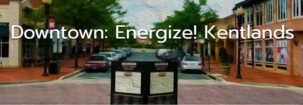
This month we were honored to have Downtown: Energize! featured in two local papers. There has been tremendous energy and enthusiasm swirling around this flagship project from SymGEO, and the technology continues to improve with every update.

lakelands newspaper

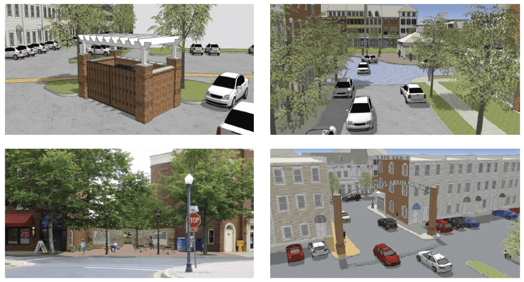
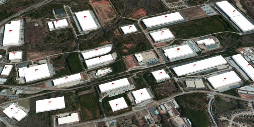
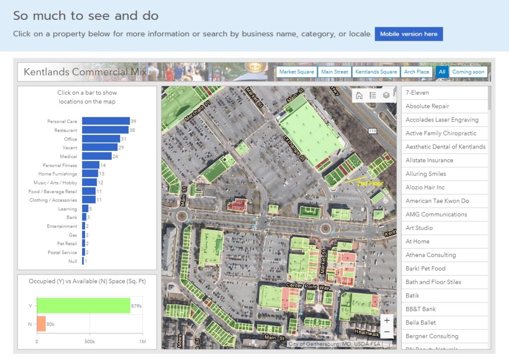
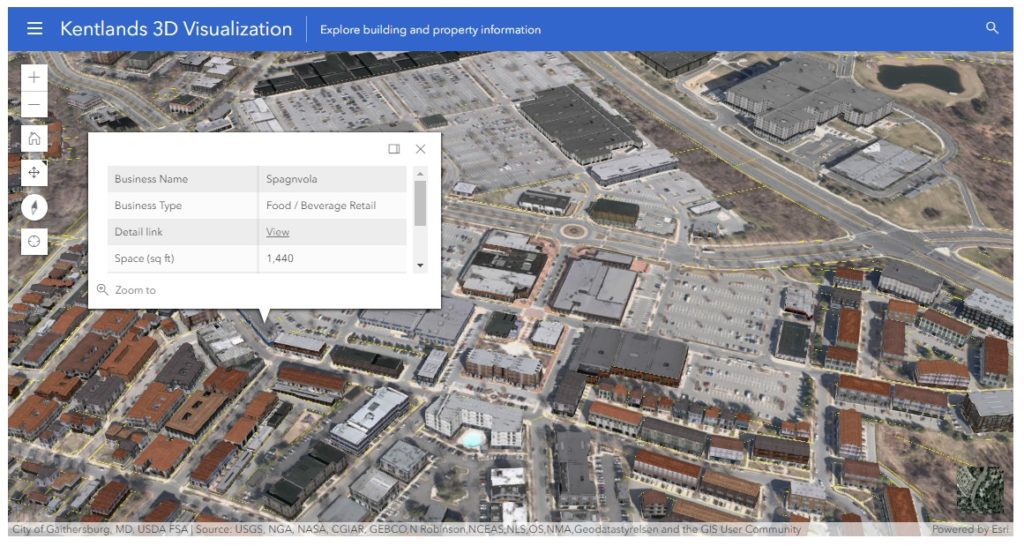
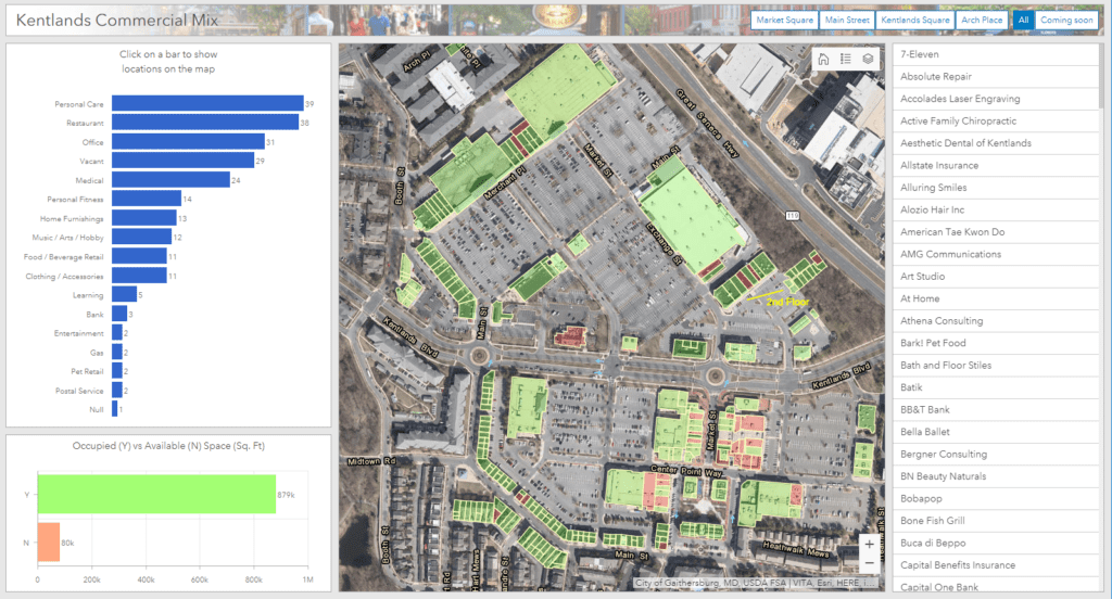
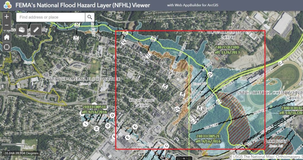
Downtown: Energize! features many different components of the ArcGIS technology suite, including Survey123, GeoForm / Collector, ArcGIS Dashboard, Web AppBuilder for the retail locator, and a web scene that uses CityEngine textured models derived from building footprints and Lidar information processed in ArcGIS Pro. These components are then hosted in ArcGIS Online and leveraged using ArcGIS Hub technology.

downtown energize banner

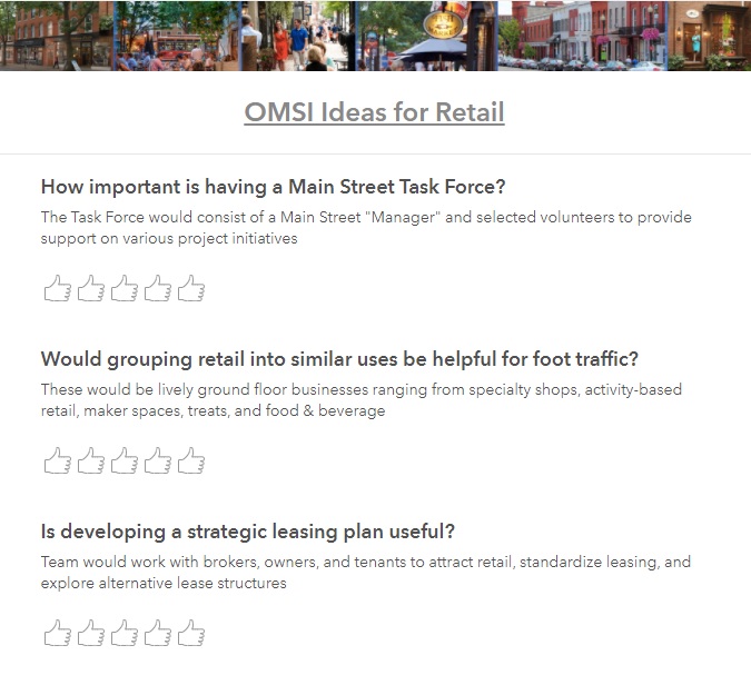
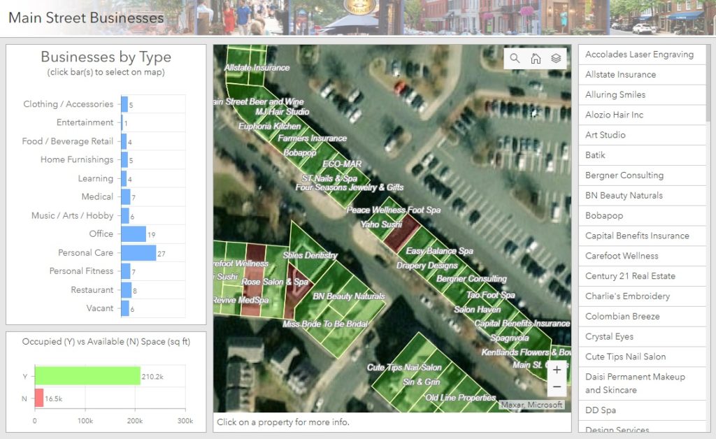
Two local development boards, the Kentlands Downtown Working Group (KDWG) and the One Main Street Initiative (OMSI), took an excited interest in Downtown: Energize! and have commissioned complimentary sites to be built using Hub technology. The commercial real-estate management of the site is especially useful in a fast-paced environment!

kentlands newspaper

“The KDWG was commissioned by the Kentlands board to provide accurate and timely information on the various development efforts going on with our downtown so residents can be better informed and take a more active role in improving our community. We chose the Downtown: Energize! platform developed by SymGEO with its innovative digital mapping because it helps do exactly that.”

– John Ingrassia, Chair, Kentlands Downtown Working Group

“A great commercial district is a huge amenity for our community. Downtown: Energize! is a great digital tool for helping the community achieve the vision for our commercial district. Not only will it help us engage the community to provide flexible two-way dialogue, but it will help us by mapping opportunities where businesses can expand and thrive. This innovative platform will allow us to easily update data, access data and provide data well beyond our community, which provides outreach to businesses looking to expand. Additionally, it is a fun way to empower consumers looking for a place to spend their precious free time to engage with this easy to use tool whether at home or mobile. Working with Kevin at SymGEO has been an amazing experience. He and his team are bringing tremendous innovations and ideas to our team at The One Mainstreet Initiative.”

– Neil Burka, Chair, One Main Street Initiative

“I was so excited when SymGEO came to us with this idea. As a local real estate agent and resident who is deeply engaged in the community, I understand on a personal level how important this spatial data is to get the community engaged and onboard with what’s happening. This platform will make it easy to access the data – especially for folks who, like me, are more visual.”

– Sheena Saydam, Realtor, Keller Williams Capital Properties, Member, Kentlands Downtown Working Group

“Downtown: Energize! as created by Kevin McMaster using the SymGEO platform, is an innovative digital tool that provides mapping of business locations to potential and existing customers in a format that is fun, easy to use, and flexible enough to accept updates and even track current events. It’s a win-win for our community by empowering residents to engage with our local businesses and to energize our downtown!”

– Ingrid L. Fraley, Local Business Owner – Design Services, Inc.

kentlands 3d

If you’d like to join the party with a Downtown: Energize! initiative, let us know as SymGEO is here to help!
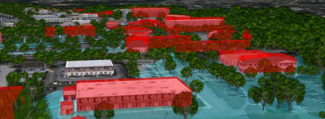
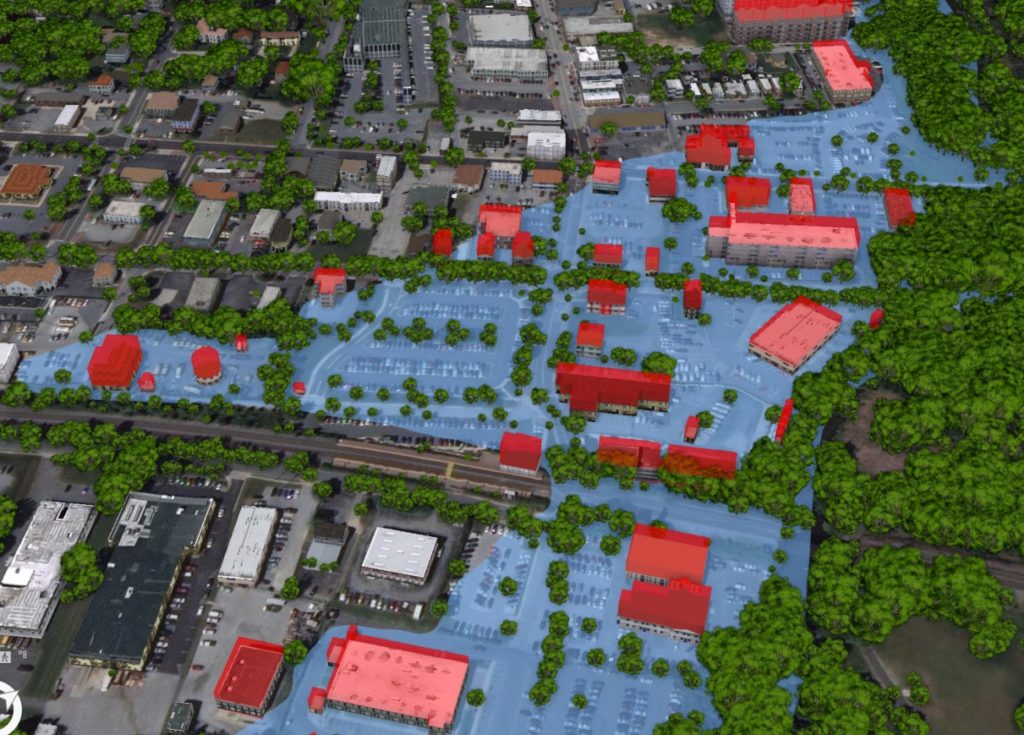
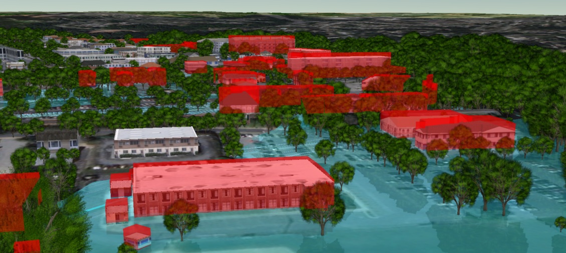
Commercial Property Management

Keeping track of who is where, what’s coming soon, square footage available, and when leases are ending can be quite a challenge when hundreds (or thousands!) of properties are involved. Fortunately, GIS is perfectly suited to this task of commercial property management, as it combines space, time, attributes and symbology into one cohesive picture.

For the Kentlands community in Gaithersburg, MD, ArcGIS Online data was used to power an initiative called Downtown: Energize!, that has garnered critical acclaim from residents and business owners alike. This Hub site designed to explore existing retail, gather community ideas, and identify opportunities for commercial business. With almost a hundred commercial properties involved, including several large commercial parcels, the data came in the usual assortment of formats (pdf, GIS, field collection). However, the end result was a cohesive framework designed to be updated and informed by the community it serves through a crowd-sourced GeoForm application.

data updater

geoform

Searching by business name was enabled through a configurable application that is embedded into the Hub site. There is also active development and building reconfiguration occurring in this area, as shown below with the current buildings overlaid on last year’s imagery. This solution provides a one-stop shop for information about current commercial businesses in the area, and a common platform for the community to use.

If your community is ready to get started with a Downtown: Energize! initiative or your business would like to use GIS as a property management tool, let us know as SymGEO is here to help!